
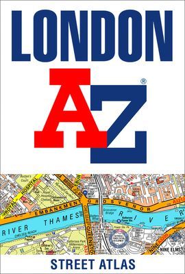
London A-Z Street Atlas (A-Z maps)(Paperback / softback) - diskuze
Výrobce: HARPERCOLLINS
EAN: 9780008663490
Výrobní číslo: 9780008663490
Navigate your way around London with this detailed, easy-to-use and up-to-date A-Z Street Atlas.First published in 1936, this iconic atlas is a trusted means of finding your way around the capital city.The main mapping extends beyond Central London from Heathrow Airport to Chingford at a scale of 2.88 inches to 1 mile (4.55 cm to 1 km), featuring postcode districts, one-way streets, the Congestion Charging Zone and Low Emission Zone.The large-scale street map of Central London – at a scale of 5.75 inches to 1 mile – cover Regent’s Park and Shoreditch, Chelsea and Vauxhall, Hyde Park and Bermondsey.A comprehensive index lists streets, selected flats, walkways and places of interest, place, area and junction names. Additional healthcare (hospitals, walk-in centres and hospices) and transport connections (National Rail, London Tramlink, Docklands Light Railway, London Underground and Overground stations, and River Bus pier) are indexed as well.Also included are:• Overview map of the Congestion Charging Zone, Ultra Low Emission and Low Emission Zones• West End Theatre map• London Connections rail services map
Cena 297 Kč v 1 obchodě
Dotazy, recenze a diskuze k London A-Z Street Atlas (A-Z maps)(Paperback / softback)
Přidat dotaz
Přidat rezenci, hodnocení
Přidat rezenci, hodnocení
 The Girl on the Train - Paula Hawkins
 ZOO - Samolepková knížka
- neuve
ZOO - Samolepková knížka
- neuve Soudné sestry - Úžasná zeměplocha - 2
  Vsuvka do Putování na západ: román na
  Umělecké památky Prahy
 English File Third Edition Upper Inter
 Kolaps a jeho d˘sledky
 Blíženci
 Hella Jongerius
 Closely Observed Trains
 Twin Peaks: The Final Dossier
 Kant a Husserl o zkušenosti - Trnka Ja






















Přidat dotaz