
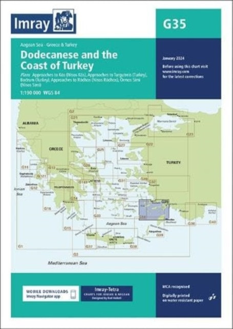
Imray Chart G35 - Dodecanese and the Coast of Turkey (Imray)(Sheet map, folded) - diskuze
Výrobce: Imray,Laurie,Norie & Wilson Ltd
EAN: 9781786795564
Výrobní číslo: 9781786795564
Plans included:Approaches to Kós (NÃsos Kós) (1:20 000)Approaches to Turgutreis (Turkey) (1:100 000)Bodrum (Turkey) (1:20 000)Approaches to Ródhos (NÃsos Ródhos) (1:30 000)Órmos SÃmi (NÃsos SÃmi) (1:40 000)Imray-Tetra charts for the Ionian and Aegean are widely acknowledged as the best available for the cruising sailor. They combine the latest official survey data with first-hand information gathered by Rod and Lucinda Heikell. The chart is designed to be used alongside Imray pilot guides of the area. Like all Imray charts, they are printed on water resistant Pretex paper for durability, and they include many anchorages, facilities and inlets not included on official charts.This edition includes the latest official data combined with additional information sourced from Imray's network to make it ideal for small craft. It includes the latest official bathymetric surveys. There has been general updating throughout.
Cena 791 Kč v 1 obchodě
Dotazy, recenze a diskuze k Imray Chart G35 - Dodecanese and the Coast of Turkey (Imray)(Sheet map, folded)
Přidat dotaz
Přidat rezenci, hodnocení
Přidat rezenci, hodnocení
 MFP Omalovánky A5 - Dino - 5300790
 Lunární dny pro ženy
 Čestní doktoři Univerzity Karlovy 1848
 RUBÁŠOVÁ TAŤÁNA William & Meriwether -
 Before We Were Yours
 Jannes Hannu, Roberts Owen,: Ptáci naš
 Babičkina lekáreň nad zlato
 Hawking Stephen W.: My Brief History
 Bestiář Harryho Pottera
 Petr Nikl - Grafika
 Iustus 2
 Botanický slovník




















Přidat dotaz